Ground Zero
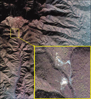
The picture is of Pungye-ri, Gilju-gun, North Hamgyong Province suspected as the site of the North Korean nuclear test, as taken by the multipurpose satellite Arirang-2 on October 16. The top of the small square is Mt. Mantap, while the bottom is Janguk stream. The dark portions are mountainous areas, while the white parts are buildings or exposed grounds.