Satellite Images of Pyongyang

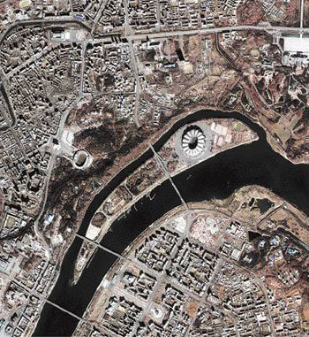
The Korea Aerospace Research Institute publicized for the first time an image of Pyongyang taken by the multipurpose satellite Arirang 2 in February. In the middle of the photo are Daedong River and Neungna Island. The circle in the island shows the location of May 1 Stadium. Gaeseonmun (triumphal arch), Kim Il Sung University, and Geumsusan Memorial are also near the island. The satellite photographs certain parts of the Korean peninsula every two or three days in a 15-kilometer swath from southeast to northwest.
Headline News
- Joint investigation headquarters asks Yoon to appear at the investigation office
- KDIC colonel: Cable ties and hoods to control NEC staff were prepared
- Results of real estate development diverged by accessibility to Gangnam
- New budget proposal reflecting Trump’s demand rejected
- Son Heung-min scores winning corner kick


