Typhoon Khanun expected to pass through South Korea
Typhoon Khanun expected to pass through South Korea
Posted August. 09, 2023 08:21,
Updated August. 09, 2023 08:21
As Typhoon Khanun steadily advances eastwards towards Seoul, South Korea braces itself for a potentially catastrophic weather event. The impending typhoon, characterized by heavy rainfall and fierce winds, is anticipated to inflict considerable damage across the nation.
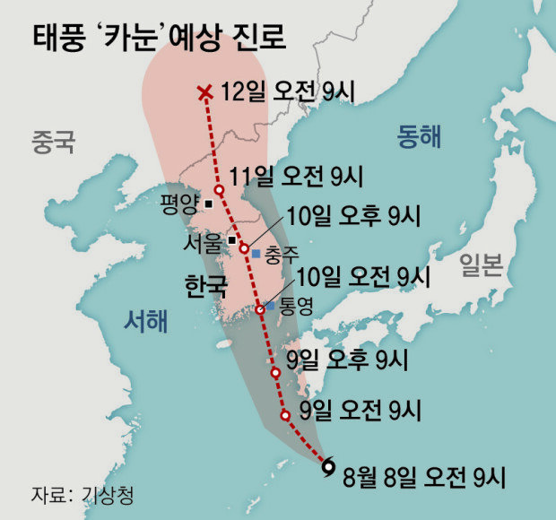
The Korea Meteorological Administration reported that Typhoon Khanun is slated to make landfall along the southern coast near Tongyeong, North Gyeongsang Province on Thursday. With maximum sustained wind speeds ranging between 33 to 44 meters per second (m.p.h.), the typhoon’s trajectory is expected to take it northwards, affecting regions like Jeonju, North Jeolla Province, where wind speeds of 22 to 32 m.p.h. are projected. A typhoon warning is set to be issued on Wednesday afternoon for Jeju, eventually extending across the southern territories, including Jeolla and Gyeongsang, and enveloping North Gyeongsang, Chungcheong, and the Seoul metropolitan area on Thursday.
Commencing on Wednesday, the typhoon will unleash a deluge of rainfall, with the most intense precipitation anticipated in Yeongdong, Gangwon Province. Over the course of Wednesday to Friday, Yeongdong is predicted to experience a relentless downpour of 200 millimeters to 600 millimeters, with hourly rates of up to 100 millimeters. The heavy rain can be attributed to the region’s geographical features, particularly its position on the powerful side of the typhoon’s radius, coupled with its proximity to the Taebaek Mountains, which foster the formation of robust rain clouds due to the uplift of moisture-laden air.
The entire nation is poised to bear the brunt of the typhoon, with severe rainstorms forecasted. The west coast of South Chungcheong and the southern coast are slated to witness hourly rainfall of 100 to 200 millimeters, and the southern coast may experience up to 300 millimeters per hour. In the Seoul metropolitan area and the western section of Gangwon province, as well as inland North Chungcheong, rainfall rates are projected to peak at 150 millimeters per hour.
Powerful winds are expected to extend their reach across expansive regions. The core of the typhoon is expected to penetrate deep inland, accompanied by a broad expanse of strong winds. High-speed gusts, potent enough to derail trains, are anticipated for parts of the southern coast of South Gyeongsang on Monday, followed by the southern coast of South Jeolla and the entirety of South Gyeongsang on Tuesday. The southern regions and Yeongdong in Gangwon Province are also at risk of encountering winds capable of blowing roofs off of buildings.
The typhoon’s trajectory may be altered depending on tropical cyclone forecasting models. The Korea Meteorological Agency underscored that changes in the typhoon’s route hinge on the expansion of the North Pacific anticyclone, the depth of the trough, and the intensity of the typhoon. “Irrespective of the specific path, the entire nation remains within the typhoon’s sphere of influence, with strong winds and heavy rainfall expected,” the KMA stated.
yeah@donga.com


Headline News
- Companies race to build key connections with the Trump administration
- Trump's key figure advises against overinterpretation of Pyongyang’s actions
- OECD lowers Korea's 2025 potential growth below 2%
- Supreme Court confirms compensation for May 18 Gwangju movement victims
- Kim Sang-kyum wins first World Cup medal in Alpine snowboarding